Major iOS Releaser
- Posts 9938
- Location ★ Blindspot ★
- WRZ$
130680.00
- Device

Spyglass v3.7.11
Requirements: Requires iOS 7.0 or later. Compatible with iPhone, iPad, and iPod touch.
Overview: Spyglass is an essential GPS toolkit for outdoors and off-road navigation.
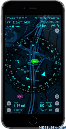
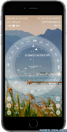
Packed with tools it serves as binoculars, heads-up display, milspec compass with maps, gyrocompass, tactical GPS receiver, waypoint tracker, speedometer, altimeter, Sun, Moon and star finder, gyro horizon, rangefinder, coordinate converter, sextant, inclinometer, angular calculator and camera. It saves your custom places and waypoints, navigates precisely to them later, shows them on maps and using real-time augmented reality displays detailed GPS info, measures distances, sizes, angles, and does a lot more.
COMPASS & GYROCOMPASS
Accuracy improvement techniques, special compass modes and calibration methods available in Spyglass only make it a real instrument – made to military standards it’s the most advanced and accurate digital compass that also supports military units.
FINDER, TRACKER & AR NAVIGATION
Spyglass operates in 3D and uses augmented reality to show real-time object positions, info and directions to them overlaid over camera or maps.
Save current position, add points from maps, manually enter location coordinates and bearings, add stars by hand or use a built-in star catalogue.
Find saved places and objects later simply by following directional arrows.
Spyglass tracks multiple targets simultaneously and shows their info – distance, direction, azimuth, elevation and estimated time of arrival.
Copy, paste and share locations, coordinates and map links using many supported formats.
TACTICAL GPS, SPEEDOMETER & ALTIMETER
Find and track your location and get detailed real-time GPS data – coordinates in dozens of civil and military formats, altitude, course, current and maximum speed, using imperial, metric, nautical and military units.
MAPS
See your and targets’ positions on maps using different map styles and alternative map providers – plan waypoints and measure distances.
TRACK STARS, SUN AND MOON & NAVIGATE BY STARS
Track positions of stars, Sun and Moon with arc second precision – use them as a reference to calibrate compass for maximum accuracy.
OPTICAL RANGEFINDER
Measure distances to objects in real time with a rangefinder reticle similar to sniper sights.
SEXTANT, ANGULAR CALCULATOR AND INCLINOMETER
Find out heights of objects and distances to them – measure visually and calculate dimensions and distances.
CAMERA
Take pictures overlaid with all available GPS, positional and directional data.
What's New :
v3.7.11
· sub-meter GPS accuracy
· compatibility with iOS 9, iPhone 6S and 6S Plus
· improved detection of coordinates in copied text
· improved resolution of taken photos and screenshots
· lots of smaller improvements and bug fixes
More Info:
Download Instructions:
https://userscloud.com/v1y8khbenztb
Mirrors:
https://dailyuploads.net/n9gavrs7z6g4
https://drop.download/2tyqdqeo92l1
Requirements: Requires iOS 7.0 or later. Compatible with iPhone, iPad, and iPod touch.
Overview: Spyglass is an essential GPS toolkit for outdoors and off-road navigation.
Packed with tools it serves as binoculars, heads-up display, milspec compass with maps, gyrocompass, tactical GPS receiver, waypoint tracker, speedometer, altimeter, Sun, Moon and star finder, gyro horizon, rangefinder, coordinate converter, sextant, inclinometer, angular calculator and camera. It saves your custom places and waypoints, navigates precisely to them later, shows them on maps and using real-time augmented reality displays detailed GPS info, measures distances, sizes, angles, and does a lot more.
COMPASS & GYROCOMPASS
Accuracy improvement techniques, special compass modes and calibration methods available in Spyglass only make it a real instrument – made to military standards it’s the most advanced and accurate digital compass that also supports military units.
FINDER, TRACKER & AR NAVIGATION
Spyglass operates in 3D and uses augmented reality to show real-time object positions, info and directions to them overlaid over camera or maps.
Save current position, add points from maps, manually enter location coordinates and bearings, add stars by hand or use a built-in star catalogue.
Find saved places and objects later simply by following directional arrows.
Spyglass tracks multiple targets simultaneously and shows their info – distance, direction, azimuth, elevation and estimated time of arrival.
Copy, paste and share locations, coordinates and map links using many supported formats.
TACTICAL GPS, SPEEDOMETER & ALTIMETER
Find and track your location and get detailed real-time GPS data – coordinates in dozens of civil and military formats, altitude, course, current and maximum speed, using imperial, metric, nautical and military units.
MAPS
See your and targets’ positions on maps using different map styles and alternative map providers – plan waypoints and measure distances.
TRACK STARS, SUN AND MOON & NAVIGATE BY STARS
Track positions of stars, Sun and Moon with arc second precision – use them as a reference to calibrate compass for maximum accuracy.
OPTICAL RANGEFINDER
Measure distances to objects in real time with a rangefinder reticle similar to sniper sights.
SEXTANT, ANGULAR CALCULATOR AND INCLINOMETER
Find out heights of objects and distances to them – measure visually and calculate dimensions and distances.
CAMERA
Take pictures overlaid with all available GPS, positional and directional data.
What's New :
v3.7.11
· sub-meter GPS accuracy
· compatibility with iOS 9, iPhone 6S and 6S Plus
· improved detection of coordinates in copied text
· improved resolution of taken photos and screenshots
· lots of smaller improvements and bug fixes
More Info:
Code: Select all
https://itunes.apple.com/app/id332639548Download Instructions:
https://userscloud.com/v1y8khbenztb
Mirrors:
https://dailyuploads.net/n9gavrs7z6g4
https://drop.download/2tyqdqeo92l1