
Major Android Releaser
- Posts 49282
- Location Pochinki
- WRZ$
227887.00
- Device OnePlus One ~ 10 Pro
OruxMaps Donate v7.0.10
Requirements: 2.3 and up
Overview: Map viewer/route logger for your outdoor activities.
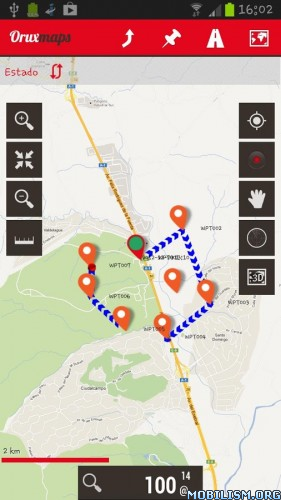
-online with many different types of maps (Google maps, OpenStreetMap, Microsoft Maps,etc.).
-offline with calibrated maps for the application. You can convert your Ozi Explorer maps, or create your own maps, with a desktop tool.
Allows you record tracks using GPS. It works with gpx and kml formats.
More features:
100% free
100% no Advertising
Map download
3D view
Text to Speech (some locales)
Wms support
Support to some .rmap maps
Support to vector maps (mapsforge)
Support to vector Garmin .img maps (not locked)
Profiles
Save/restore preferences
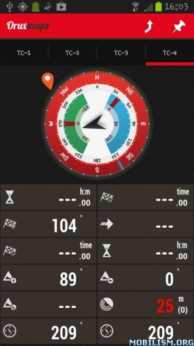
Complete track statistics, with different graphs
External bluetooth GPS support
Export your tracks in KML/GPX/KMZ formats
Follow your old tracks/routes, with distance alarm.
Save Waypoints with attached photo-audio-video media files. Wpt proximity alarm with custom audio alarm
Waypoint navigation mode
Geocaching support
Custom cursor images
Power save mode, for long track recording
Use a heart monitor with your device (supported Zephyr HRM, Polar Bluetooth and ANT+)
Upload/download tracks from everytrail.com
Upload tracks to gpsies.com, mapmytracks.com and trainingstagebuch.org
Live tracking with mapmytracks.com
WHAT'S NEW
News v.7.0.10:
—>Voice messages based on time.
—>Actions added to recording notification.
—>Bugs correction
This app has no advertisements
More Info:
Download Instructions:
https://dailyuploads.net/2gjbvdy0js4l
Mirror:
https://drop.download/txm9t7amwku4
(Closed Filehost) https://ul.to/wya8or4w
Requirements: 2.3 and up
Overview: Map viewer/route logger for your outdoor activities.
-online with many different types of maps (Google maps, OpenStreetMap, Microsoft Maps,etc.).
-offline with calibrated maps for the application. You can convert your Ozi Explorer maps, or create your own maps, with a desktop tool.
Allows you record tracks using GPS. It works with gpx and kml formats.
More features:
100% free
100% no Advertising
Map download
3D view
Text to Speech (some locales)
Wms support
Support to some .rmap maps
Support to vector maps (mapsforge)
Support to vector Garmin .img maps (not locked)
Profiles
Save/restore preferences
Complete track statistics, with different graphs
External bluetooth GPS support
Export your tracks in KML/GPX/KMZ formats
Follow your old tracks/routes, with distance alarm.
Save Waypoints with attached photo-audio-video media files. Wpt proximity alarm with custom audio alarm
Waypoint navigation mode
Geocaching support
Custom cursor images
Power save mode, for long track recording
Use a heart monitor with your device (supported Zephyr HRM, Polar Bluetooth and ANT+)
Upload/download tracks from everytrail.com
Upload tracks to gpsies.com, mapmytracks.com and trainingstagebuch.org
Live tracking with mapmytracks.com
WHAT'S NEW
News v.7.0.10:
—>Voice messages based on time.
—>Actions added to recording notification.
—>Bugs correction
This app has no advertisements
More Info:
Code: Select all
https://play.google.com/store/apps/details?id=com.orux.oruxmapsDonateDownload Instructions:
https://dailyuploads.net/2gjbvdy0js4l
Mirror:
https://drop.download/txm9t7amwku4
(Closed Filehost) https://ul.to/wya8or4w

