
Major Android Releaser
- Posts 57889
- Location Kraków
- WRZ$
301231.25
- Device Pixel 6 Pro
- OS Android 14
World atlas & world map MxGeo Pro v6.2.84
Requirements: 4.4+
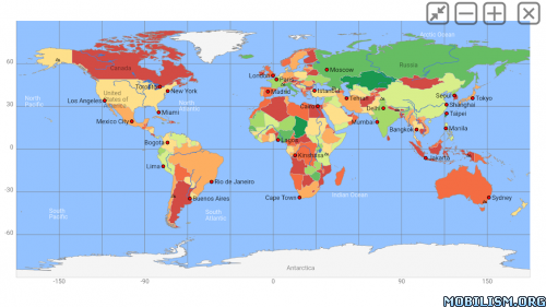
Overview: World atlas, world map and educational app for geography. Contains 240 countries and territories of the world with comprehensive economic and geopolitical data. Political maps with regional units (provinces), capitals and major cities included.
Designed for smartphones and tablets.
• Maps, flags and comprehensive data for 240 countries and territories of the world
• Interactive political world, continent and country maps
• Shaded relief layer for world and continent maps
• Geography quiz challenge for playful learning
• Country comparison and favorites
• Configurable world clock with time zone display
• World-explorer: the smallest, largest, wealthiest, and most populated countries of the world
• Selectable color themes for map display
• All data and maps included, no online connection required
• No advertising or In App Purchases
• No permissions required
Explore the world through political continent and country offline maps. Whether Europe, Africa, Asia, Oceania, South and North America: maps of all continents and countries are included. Learn where each country in the world is located. View its position highlighted on a digital globe. Create your favorite color theme or choose from different color schemes for map display.
Do you know the flag of Mauritius? Yes? Perfect. Do you also know in which country the Mount Everest is located? “World atlas & world map MxGeo Pro” Quiz helps you acquire a geographic literacy in a playful manner.
Choose from six geo guessing games:
• Test your knowledge about the capitals in the world
• Recognize the proper country flag based on the outline map
• Do you know the top-level domains of the world's countries?
• Guess the highlighted country on the virtual globe
• Do you know the ISO countries codes of the world?
• Do you know the mountains of the world?
Each quiz offers seven regional variants: World, Europe, Africa, Asia, Oceania, South or North America.
Geo learning app and educational game which is fun for everyone whether children, adults, seniors or teachers. Get ready for your next stay abroad while enjoying this great world almanac including time zones and statistical data, such as population growth, unemployment rate, average age, gross domestic product (GDP) by sector and other key figures. Or prepare for your next geography lesson with this genius digital world map. If not traveling our world atlas lets you explore the world just only virtually.
Enjoy the comprehensive atlas of the World including Europe, Asia, North America, Africa, Oceania and South America with all countries and regional units, capitals and flags.
What’s New:
• Corrections and updates for maps and data
• Bug fixes and improvements
6.x:
• New: dynamic scale bar
• New: country data now including info about government type, climate and date of independence
• Distance calculator: more cities
• Virtual World Tour
This app has no advertisements
More Info:
Download Instructions:
(Closed Filehost) http://www.uploadship.com/c8634155ad162e4a
Mirrors:
https://uploadrar.com/bd6sah8ve087
https://drop.download/hc9ecfnob6lc
Requirements: 4.4+
Overview: World atlas, world map and educational app for geography. Contains 240 countries and territories of the world with comprehensive economic and geopolitical data. Political maps with regional units (provinces), capitals and major cities included.
Designed for smartphones and tablets.
• Maps, flags and comprehensive data for 240 countries and territories of the world
• Interactive political world, continent and country maps
• Shaded relief layer for world and continent maps
• Geography quiz challenge for playful learning
• Country comparison and favorites
• Configurable world clock with time zone display
• World-explorer: the smallest, largest, wealthiest, and most populated countries of the world
• Selectable color themes for map display
• All data and maps included, no online connection required
• No advertising or In App Purchases
• No permissions required
Explore the world through political continent and country offline maps. Whether Europe, Africa, Asia, Oceania, South and North America: maps of all continents and countries are included. Learn where each country in the world is located. View its position highlighted on a digital globe. Create your favorite color theme or choose from different color schemes for map display.
Do you know the flag of Mauritius? Yes? Perfect. Do you also know in which country the Mount Everest is located? “World atlas & world map MxGeo Pro” Quiz helps you acquire a geographic literacy in a playful manner.
Choose from six geo guessing games:
• Test your knowledge about the capitals in the world
• Recognize the proper country flag based on the outline map
• Do you know the top-level domains of the world's countries?
• Guess the highlighted country on the virtual globe
• Do you know the ISO countries codes of the world?
• Do you know the mountains of the world?
Each quiz offers seven regional variants: World, Europe, Africa, Asia, Oceania, South or North America.
Geo learning app and educational game which is fun for everyone whether children, adults, seniors or teachers. Get ready for your next stay abroad while enjoying this great world almanac including time zones and statistical data, such as population growth, unemployment rate, average age, gross domestic product (GDP) by sector and other key figures. Or prepare for your next geography lesson with this genius digital world map. If not traveling our world atlas lets you explore the world just only virtually.
Enjoy the comprehensive atlas of the World including Europe, Asia, North America, Africa, Oceania and South America with all countries and regional units, capitals and flags.
What’s New:
• Corrections and updates for maps and data
• Bug fixes and improvements
6.x:
• New: dynamic scale bar
• New: country data now including info about government type, climate and date of independence
• Distance calculator: more cities
• Virtual World Tour
This app has no advertisements
More Info:
Code: Select all
https://play.google.com/store/apps/details?id=de.mediaz.mxapp.hpbgeodeDownload Instructions:
(Closed Filehost) http://www.uploadship.com/c8634155ad162e4a
Mirrors:
https://uploadrar.com/bd6sah8ve087
https://drop.download/hc9ecfnob6lc
