
Major Android Releaser
- Posts 57889
- Location Kraków
- WRZ$
301229.25
- Device Pixel 6 Pro
- OS Android 14
Air VFR GPS- International Stand Alone Navigation v2.5 [Paid]
Requirements: 4.0+
Overview: Just Released Version 1.91 with updated screens for High Density Devices. This includes a updated Airport Database with Contact Frequencies, geographic location (from Google Servers), and all runways.
Just Released Version 1.91 with updated screens for High Density Devices. This includes a updated Airport Database with Contact Frequencies, geographic location (from Google Servers), and all runways. This release contains the Radio Frequencies and Runway information in a new screen called the INFO screen. This is a no charge upgrade and is fully functional without a data connection. Email us if you have questions or suggestions about this upgrade.
This fully self contained tool will guide you to any airport, Vor, or Point of Interest in the world. No downloads, no subscriptions, no ads, updates are free.
The Map Screen requires a temporary data connection for automatic downloading.
This GPS based system is a quick and extremely simple full Guidance and Navigation tool for pilots to enjoy the view from the sky without wasting precious flying time with complicated navigation instruments. Searches and easily provides guidance to any airport, Radio VOR, or Point of Interest(any LAT/LON combination) in the world.
The Navigation screen works well on either a smartphone or tablet computers. If you fly multiple planes, you will have one portable familiar navigation tool that you can rely upon.
It only takes 5 to 10 minutes to learn how to get to any airport, anywhere in the world. Search airport descriptions, identifiers, or nearest lists. Pick a spot on the map and with a single press insert it into your flight plan and immediately see the bearing, bearing line, and distance to that location from your current GPS location.
Search for Airports, VOR's, and NDB's. Search for "nearest airports to any airport in your flight plan" capability from the flight plan screen.
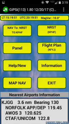
Unique Where Screen. Designed to aid the pilot by providing information to aid location identification to ATC.
You can export, import and edit your flight plan on your device or save and edit multiple versions on any computer. This is easily done to any cloud service, such as Google Drive.
EASY TO USE:
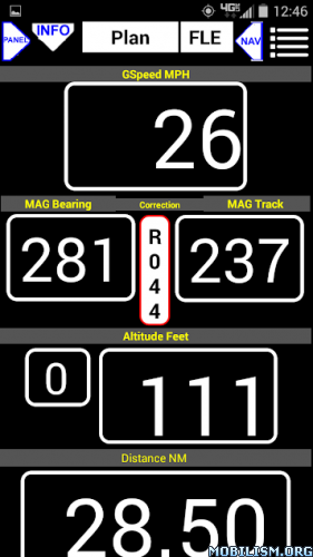
Press NEAREST for the nearest 50-100 runways, press (select) the airport you want, and follow the bearing or track on the map, verbally if you wish. This App shows a single prompt (R)ight or (L)eft and the number of degrees, Eg. "L005" for turn left 5 degrees. Easy. It also shows Ground Track, Bearing, Ground Speed, Altitude, Distance to Airport and Estimated Time of Arrival at current speed.
Press MAP and you have a moving map with "Press and Go." With the map visible, press any place on the map and the Lat/Lon from that location will be stored in the destination list.
Choose to immediately navigate to that location. In this case the navigation bearing line will be redrawn. Edit the name of the location in the Flight Plan screen at any time
If you check the MAP screenshot on this page, you can see that to navigate to your destination, just turn to the plane until the track (black with pointer) line is coincident with the RED Bearing line.. The bearing line can be re draw to start from your current location anytime.
Any airport in our world database can be found by ICAO or a word or phrase from the Description. For example, "paris" would return 25 runways to select from.
VIEW YOUR FLIGHT.
There is a point logging feature. In the air, every 30 seconds a Lat/Lon point is stored along with Altitude and Ground Speed. The Point Log can be emailed to your computer and opened with Excel or other compatible program. A hyper link is included to see that location on Google Maps.
There is an automatic Log Book feature that automatically records time in the air. The Log Book stores your flight hours as well as your Type Aircraft and Tail Number. The Log Book can be started ir stopped manually.
For further information, please email us at support@gipsinavigation.com or call us at 650-323-0148
If you have any question or issue with this app, please email or call us to resolve it.
Whats New:
Accuracy and enhancements to the Moving Map plus Automatic street address lookup for any address in the world you wish to make a destination. This can be done from the Moving Map Options or the Flight Plan.
This app has no advertisements
More Info:
Download Instructions:
https://userupload.net/ardkq9eyfjia
Mirrors:
https://uploadrar.com/pd59of91akug
https://dropgalaxy.vip/p06dsa6h54hc
Requirements: 4.0+
Overview: Just Released Version 1.91 with updated screens for High Density Devices. This includes a updated Airport Database with Contact Frequencies, geographic location (from Google Servers), and all runways.
Just Released Version 1.91 with updated screens for High Density Devices. This includes a updated Airport Database with Contact Frequencies, geographic location (from Google Servers), and all runways. This release contains the Radio Frequencies and Runway information in a new screen called the INFO screen. This is a no charge upgrade and is fully functional without a data connection. Email us if you have questions or suggestions about this upgrade.
This fully self contained tool will guide you to any airport, Vor, or Point of Interest in the world. No downloads, no subscriptions, no ads, updates are free.
The Map Screen requires a temporary data connection for automatic downloading.
This GPS based system is a quick and extremely simple full Guidance and Navigation tool for pilots to enjoy the view from the sky without wasting precious flying time with complicated navigation instruments. Searches and easily provides guidance to any airport, Radio VOR, or Point of Interest(any LAT/LON combination) in the world.
The Navigation screen works well on either a smartphone or tablet computers. If you fly multiple planes, you will have one portable familiar navigation tool that you can rely upon.
It only takes 5 to 10 minutes to learn how to get to any airport, anywhere in the world. Search airport descriptions, identifiers, or nearest lists. Pick a spot on the map and with a single press insert it into your flight plan and immediately see the bearing, bearing line, and distance to that location from your current GPS location.
Search for Airports, VOR's, and NDB's. Search for "nearest airports to any airport in your flight plan" capability from the flight plan screen.
Unique Where Screen. Designed to aid the pilot by providing information to aid location identification to ATC.
You can export, import and edit your flight plan on your device or save and edit multiple versions on any computer. This is easily done to any cloud service, such as Google Drive.
EASY TO USE:
Press NEAREST for the nearest 50-100 runways, press (select) the airport you want, and follow the bearing or track on the map, verbally if you wish. This App shows a single prompt (R)ight or (L)eft and the number of degrees, Eg. "L005" for turn left 5 degrees. Easy. It also shows Ground Track, Bearing, Ground Speed, Altitude, Distance to Airport and Estimated Time of Arrival at current speed.
Press MAP and you have a moving map with "Press and Go." With the map visible, press any place on the map and the Lat/Lon from that location will be stored in the destination list.
Choose to immediately navigate to that location. In this case the navigation bearing line will be redrawn. Edit the name of the location in the Flight Plan screen at any time
If you check the MAP screenshot on this page, you can see that to navigate to your destination, just turn to the plane until the track (black with pointer) line is coincident with the RED Bearing line.. The bearing line can be re draw to start from your current location anytime.
Any airport in our world database can be found by ICAO or a word or phrase from the Description. For example, "paris" would return 25 runways to select from.
VIEW YOUR FLIGHT.
There is a point logging feature. In the air, every 30 seconds a Lat/Lon point is stored along with Altitude and Ground Speed. The Point Log can be emailed to your computer and opened with Excel or other compatible program. A hyper link is included to see that location on Google Maps.
There is an automatic Log Book feature that automatically records time in the air. The Log Book stores your flight hours as well as your Type Aircraft and Tail Number. The Log Book can be started ir stopped manually.
For further information, please email us at support@gipsinavigation.com or call us at 650-323-0148
If you have any question or issue with this app, please email or call us to resolve it.
Whats New:
Accuracy and enhancements to the Moving Map plus Automatic street address lookup for any address in the world you wish to make a destination. This can be done from the Moving Map Options or the Flight Plan.
This app has no advertisements
More Info:
Code: Select all
https://play.google.com/store/apps/details?id=com.aviation.sixpacklogDownload Instructions:
https://userupload.net/ardkq9eyfjia
Mirrors:
https://uploadrar.com/pd59of91akug
https://dropgalaxy.vip/p06dsa6h54hc
