
GPS Moderator
- Posts 1546
- WRZ$
33296.70
- Device GPSMap276c, Nuvi 1450T, Montana 600, Monterra, Virb
- OS Android 10
Garmin - City Navigator North America NT 2014.10
Requirements: garmin devices, PC
Overview: Navigate the streets with confidence. City Navigator North America provides detailed road maps and points of interest for your compatible Garmin GPS device, so you can navigate with exact, turn-by-turn directions to any address or intersection.
Features
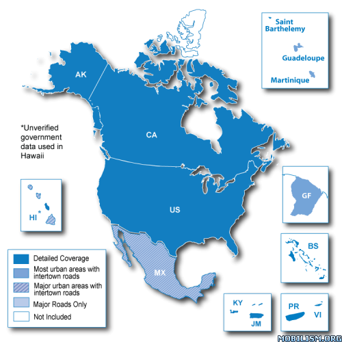
Includes coverage of the U.S., Canada and Mexico, including Puerto Rico, U.S. Virgin Islands, Cayman Islands and The Bahamas. Also contains new additional coverage of French Guiana, Guadeloupe, Martinique and Saint Barthélemy.
Provides over 10 million points of interest, including hotels, restaurants, parking, entertainment, fuel and shopping.
Includes highways, interstates, and business and residential roads in metropolitan and rural areas.
Includes turn restrictions, roundabout guidance, speed categories.
Gives turn-by-turn directions.
Includes postal code support for Canada.
Contains traffic data for compatible devices with traffic receivers.
Speaks street names (example: “Turn right on Main Street.”).
More Information
Download Instructions:
City Navigator North America NT 2014.10 or Download City Navigator North America NT 2014.10
MapID: 2920
password: ozboss18
inside
unlocked gmap folder
hoster
netload.in
share-online.biz
Requirements: garmin devices, PC
Overview: Navigate the streets with confidence. City Navigator North America provides detailed road maps and points of interest for your compatible Garmin GPS device, so you can navigate with exact, turn-by-turn directions to any address or intersection.
Features
Includes coverage of the U.S., Canada and Mexico, including Puerto Rico, U.S. Virgin Islands, Cayman Islands and The Bahamas. Also contains new additional coverage of French Guiana, Guadeloupe, Martinique and Saint Barthélemy.
Provides over 10 million points of interest, including hotels, restaurants, parking, entertainment, fuel and shopping.
Includes highways, interstates, and business and residential roads in metropolitan and rural areas.
Includes turn restrictions, roundabout guidance, speed categories.
Gives turn-by-turn directions.
Includes postal code support for Canada.
Contains traffic data for compatible devices with traffic receivers.
Speaks street names (example: “Turn right on Main Street.”).
More Information
Code: Select all
https://buy.garmin.com/shop/shop.do?pID=1456&pvID=83388Download Instructions:
City Navigator North America NT 2014.10
or Download City Navigator North America NT 2014.10 MapID: 2920
password: ozboss18
inside
unlocked gmap folder
hoster
netload.in
share-online.biz

- Posts 692
- WRZ$
4891.60
GPS Moderator
- Posts 1546
- WRZ$
33296.70
- Device GPSMap276c, Nuvi 1450T, Montana 600, Monterra, Virb
- OS Android 10
use MapSource, BaseCamp or Mapinstall
copy unpacked gmap folder in garmin map directory
WIN7/Vista = C:\ProgrammData\Garmin\Maps
or
XP = C:\Dokument and Setting\All Users\ApplicationData\Garmin\Maps
on MAC OS
/Users/PUTYOURUSERNAMEHERE/Library/Application Support/Garmin/Maps/
and the programs see the map and you can create your own image

Please help, I am desperate.
I downloaded all maps, etc.from this thread. When I tried to install them using Mapinstall, there was not enough space on Nuvi 255w (I made sure to select only continental US from map, so as to not go too far over the size of the original .img file I had). So, I backed up gmapprom.img to my mac desktop. Then I deleted gmapprom.img from nuvi. I then tried to install maps, and still not enough room. Strangely it shows less than 500mb free space on nuvi, despite the deleted .img file being around 1.24gb. Then when I try to use nuvi, it says that maps aren't installed, so I tried to move the copied files from my desktop back to nuvi, and it now tells me that there is not enough room for them?! Is there another file I should have deleted from nuvi in order to free space for the new maps? Or, is there at least a way to get the old maps working again?
Any thoughts?
I have updated maps before with .img files found here in this forum, but the .gmap file type in this thread seems to have really confused me.
Your help would REALLY be appreciated, since I am stumped, and my garmin is now unusable, and I am leaving on an out of town roadtrip in a few days
Thanks so much!
Thanks so much for your reply.
I did as instructed in post 5, but i didn't see how to create the .img file. They are both able to see and use the map, bu I don't know how to create th .img with it. I thought perhaps it creats it automatically, but I couldn't find the .img anywhere. I tried with base camp, as well as map install, but just couldn't figure it out
Also, is there a way to create a .img of only the continental US, in order for it to use less space?
Or, is there anywhere you know of, that a .img file can be downloaded?
Thank you again for being so kind as to help me.
GPS Moderator
- Posts 1546
- WRZ$
33296.70
- Device GPSMap276c, Nuvi 1450T, Montana 600, Monterra, Virb
- OS Android 10
Thank you for all your help!
Sadly, I guess I will have to just get used to not having gps, since I can't afford a new one. For some reason when I deleted the original .img file, the space is still showing as used on the unit, so there is not room for the new map. Even the original gmapprom.img file will not fit, due to not enough room available
Thanks again, and if you are in the USA, have a very HAPPY 4th of July!