Boating Europe HD v10.9.2
Requirements: iOS 9.0 or later. Compatible with iPad.
Overview: The world’s #1 Boating app!
A favorite among cruisers, sailors, fishermen and divers. Find the same detailed charts and advanced features as on the best GPS plotters. This app includes the Navionics+ subscription. To subscribe for other areas, tap Menu>Charts>Add Region. Alternatively, a free version is also available on the store that offers basic features and you can upgrade to Navionics+ In-App.
NAVIONICS+ includes:
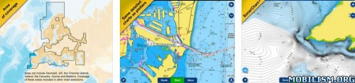
√ Download of the following chart layers:
-NAUTICAL CHART for all essential cartographic reference detail. The most accurate and thorough set of information based on Hydrographic Office data, Notices to Mariners, new publications, our own surveys, and reports from users. It provides port plans, safety depth contours, marine services info, tides & currents, navigation aids and more.
-SONARCHART™ the award-winning 1 ft/0.5m HD bathymetry map that reflects ever-changing conditions. Be part of the community and contribute by uploading your sonar logs to enhance it.
- COMMUNITY EDITS made by users (rocks, wrecks, etc.) and shared for all to benefit.
√ CHART UPDATES: we deliver more than 2,000 updates every day! Updates as frequently as you like!
√ DOCK-TO-DOCK AUTOROUTING creates detailed routes even through narrow waterways and channels, based on chart data and navigation aids. POIs are automatically shown nearby your destination.
√ NAVIGATION MODULE for advanced route planning with ETA, distance to arrival, heading to WP, fuel consumption and more!
√ ADVANCED MAP OPTIONS: overlay Satellite/Terrain, highlight Shallow Areas, filter Depth Contours, and enable a Fishing Range to target key fishing areas.
√ PLOTTER SYNC: Compatible Raymarine, Lowrance, Simrad and B&G models can transfer routes and markers, update charts, activate and renew subscriptions of eligible plotter cards and upload sonar logs (only Raymarine) for improved SonarChart™! Learn more at navionics.com/charts/features/plotter-sync.
√ WEATHER & TIDES provides real-time weather data and forecasts. Access daily and hourly forecasts for your favorite locations and get wind, weather buoys, Tides & Currents overlaid on your map.
√ TIMELINE where you can see all the photos taken while tracking, POIs and Navionics panoramic images.
More Info:
Download Instructions:
https://douploads.net/ngv3jzbyui45
(Closed Filehost) https://ul.to/qp1txz2x
Requirements: iOS 9.0 or later. Compatible with iPad.
Overview: The world’s #1 Boating app!
A favorite among cruisers, sailors, fishermen and divers. Find the same detailed charts and advanced features as on the best GPS plotters. This app includes the Navionics+ subscription. To subscribe for other areas, tap Menu>Charts>Add Region. Alternatively, a free version is also available on the store that offers basic features and you can upgrade to Navionics+ In-App.
NAVIONICS+ includes:
√ Download of the following chart layers:
-NAUTICAL CHART for all essential cartographic reference detail. The most accurate and thorough set of information based on Hydrographic Office data, Notices to Mariners, new publications, our own surveys, and reports from users. It provides port plans, safety depth contours, marine services info, tides & currents, navigation aids and more.
-SONARCHART™ the award-winning 1 ft/0.5m HD bathymetry map that reflects ever-changing conditions. Be part of the community and contribute by uploading your sonar logs to enhance it.
- COMMUNITY EDITS made by users (rocks, wrecks, etc.) and shared for all to benefit.
√ CHART UPDATES: we deliver more than 2,000 updates every day! Updates as frequently as you like!
√ DOCK-TO-DOCK AUTOROUTING creates detailed routes even through narrow waterways and channels, based on chart data and navigation aids. POIs are automatically shown nearby your destination.
√ NAVIGATION MODULE for advanced route planning with ETA, distance to arrival, heading to WP, fuel consumption and more!
√ ADVANCED MAP OPTIONS: overlay Satellite/Terrain, highlight Shallow Areas, filter Depth Contours, and enable a Fishing Range to target key fishing areas.
√ PLOTTER SYNC: Compatible Raymarine, Lowrance, Simrad and B&G models can transfer routes and markers, update charts, activate and renew subscriptions of eligible plotter cards and upload sonar logs (only Raymarine) for improved SonarChart™! Learn more at navionics.com/charts/features/plotter-sync.
√ WEATHER & TIDES provides real-time weather data and forecasts. Access daily and hourly forecasts for your favorite locations and get wind, weather buoys, Tides & Currents overlaid on your map.
√ TIMELINE where you can see all the photos taken while tracking, POIs and Navionics panoramic images.
More Info:
Code: Select all
https://itunes.apple.com/au/app/boating-europe-hd/id409794756?mt=8Download Instructions:
https://douploads.net/ngv3jzbyui45
(Closed Filehost) https://ul.to/qp1txz2x